Download the USGS dataset for this region, and you’ll find yourself staring at something that looks like the skin on a Sharpei.
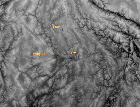
Because it’s a big file and takes some time to download, I have edited a small section and added a couple of major towns for reference. The purple dot in the middle, with no name, is Jinghong, on the banks of the Mekong.
Google Earth is useful for similar reasons, as one can get a good idea of the topography of the area.
For the likes of Google however, Xishuangbanna is undoubtedly a cartographic backwater: some of the images are years out of date.
I’ve spent a fair bit of time in the last two years pawing over Google maps, and the less popular Microsoft Maps (now Bing).
It would be an exaggeration to say that oxbow lakes have formed since Google updated some of its images, but it’s close: rivers have certainly changed their courses, villages have disappeared, highways have been built: the main highway from Jinghong to the Lao border, which was finished soon after I first came here seven years ago, is still not on the satellite images.
A while back, I was with a friend in the mountains, and we were identifying villages as we went. I asked a couple of times about a village I had seen on Google satellite images, but my friend was insistent that no such village existed. On arriving back home I compared Google and Bing images. In the former photo there was a village, in the latter, no village. The entire village had moved and been razed. My friend had no recollection of the village, but it was surely there some years ago.
This particular image was updated at the beginning of March 2013. The previous image was from 2001. A lot can happen in twelve years.

Google Earth image. Puxi Lao Zhai. Dated January 2001
What’s good about this is that Google provides an historical reference. Many roads have been built or changed and villages moved in the last decade, and many of Google’s images of this area date from 2001/2.

Google Earth image. Puxi Lao Zhai. Dated March 2013
Bing generally has better resolution pictures, and is more up to date, but it’s good to reference them both for comparison – not least because of cloud cover, as in the image above. The resolution on recent Google images is much better than earlier photographs: older images can often look like this:

Me Yang – Google
Rather than this:

Me Yang – Bing
So a caveat for Puer drinkers who are inclined to spend hours on Google or Bing trying to find exactly where their favourite tea comes from. Amazing as Google and Bing are – who would have imagined ten years ago that this kind of information would be freely available – they have their limitations.